Written by Daniel Stuart
With much buzz around Rocky Point, plans start to form for the transformation of forest to trails. Below is an outline of this year’s plan written with a map showing the general flow and size compared to existing trails and the lease boundary. Please be courteous and stay off the trails in development before they are officially opened. Riding before they have a chance to settle in will mess up the tread surface especially in clearcuts.
Current plans for the 2021 build season include:
- 1 mile blue/green trail that traverses along the high western side of the property. This trail will open up the more southern areas of the property
- 2 mile blue, 1000′ descent on the south side (and a 0.5 mile climb back out)
- SMA, a 0.5 mile blue descent in the center of the south side. opened December 6th
- TMU, a 0.6 mile green climb in the center of the south side , opened December 6th
- 0.5 mile blue/black descent on the north side
- 2.5 mile green loop around the Skeet chute/Pipeline ridge
total: 6 miles
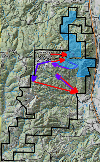
Legend:
- purple – traverse or climb
- red – descend
- blue area – existing trails
- black line – lease boundary
The NWTA Rocky Point Recreation Area is a leased property. NWTA members in good standing, have signed the online Rocky Point Waiver, have access to the area. To Become an NWTA member, head here: JOIN US!